#SEVERE WEATHER WITH TORNADOES EXPECTED ACROSS #ATLANTA & N&C #GA MON NIGHT INTO WED AM #gawx #atlwx

111SEV_OUT_APR_28_14_SE_USA

(STORM WATCH ATLANTA) ATLANTA GA
SUNDAY APRIL 27TH 2014 12:00 PM ET

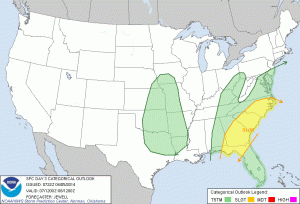
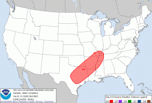
Looks like the biggest severe weather outbreak of the year is set to hit the southeast this coming week with several rounds of severe weather. All types of severe weather will be possible including the threat for tornadoes. Although severe weather will be possible as several rounds of thunderstorms move into and across the state Monday into Wednesday, the highest chance for severe weather and tornadoes will be Monday night and again from Tuesday morning all day into late Tuesday night. 2 to 4″ of rain will also be possible from Monday into Thursday.

Looks like North GA will see the highest risk for severe weather on Monday as the risk moves to the entire area for Tuesday and towards the coast by Wednesday. This will be a multi day event as a upper level low moves across the northern US and a slow moving cold front will move into and across the area.

Now is the time to plan for severe weather. Know where you and your family will go in the event a tornado warning is issued for your area. Have your NOAA Weather Radio set to ALERT mode next several days. If you dont have a weather radio, Get a free APP for your IPhone where you can get severe weather alerts.

Please stay with all week for continuing coverage of this still developing weather event. We will be here all week monitoring the latest weather.

Please follow us on Twitter @stormwchatlanta for the latest watches, warnings, and storm reports.

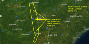
ISOLATED #SEVERE STORMS POSSIBLE MONDAY IN WEST #GA. #TORNADO POSSIBLE #gawx

SEVERE_MON_4_14_14

(STORM WATCH ATLANTA) ATLANTA GA
SUNDAY MARCH 13TH 2014 1:10 PM ET

A strong cold front is headed this way! This should produce a severe weather outbreak in AL on Monday. Before the front arrives, temps will be in the 70s and 80s Monday across the southeast. After the front moves across the southeast, night time lows on Wednesday into Thursday will drop one more time back into the 30s. The front will be so strong and all severe weather ingredients indicate there could be a few tornadoes, mainly across central AL, but there could be one or two into west GA late afternoon Monday into Monday evening.

The main threat from severe storms on Monday in Atlanta and areas to the west will be damaging winds, some minor flooding and large hail. Large hail appears to the the highest threat of all at this time.

The best time for severe weather is far NW and west central GA on Monday will be from 3pm to 9pm. As the storms move into areas east of Atlanta, the storms should weaken, but will fire up again Tuesday along the coast. Rain will continue on Tuesday, but no severe weather is expected.

Please stay with us for further updates. You can get live severe weather updates anytime @stormwchatlanta on Twitter along with the latest watches, warnings, and storm reports.
David Dutton
Storm Watch Atlanta

#DEVELOPING #SEVERE #WX EXPECTED MONDAY IN #GA. #TORNADO POSSIBLE

11severewxmonday

(STORM WATCH ATLANTA) ATLANTA GA
5:45 PM ET SAT 4/5/14

There is a risk of severe weather on Monday across much of Georgia. The main threat will be heavy rain, and damaging winds, but a few tornadoes will also be possible. The best chance of severe weather on Monday will be across central and southern GA. However, a few severe storms will be possible across north-central GA as well mainly south and east of a I-85 line. A cool wedge appears to hamper severe weather at this time across the north GA mnts and north Atlanta.

2 to 3 inches of rain will be possible also across all of the state. 2″ or more is expected across metro Atlanta, with up to 3″ possible in the mountains.

The best timing on severe weather Monday will be from 1pm to 8pm from Atlanta southeast into central and southern GA. Very heavy rain will be with you across North GA and Atlanta as you wake up for work and head to work and should last into early afternoon. Please be advised, streets maybe flooding as you head to work Monday morning. Reduce speeds and drive carefully!

I will be here all weekend into Monday to keep you up to date on this still developing weather situation. Please stay alert for future updates, as timing and locations of severe weather may change.

David Dutton
Storm Watch Atlanta

#DEVELOPING ISOLATED #SEVERE STORMS POSSIBLE FRIDAY IN #ATLANTA

bk_ltg2

(STORM WATCH ATLANTA) ATLANTA GA
2:55 PM ET THU 4/3/14

There is a “slight risk” for severe thunderstorms Friday across Atlanta and most of northern and western GA. The main threat will be damaging winds. The best chance you would see a severe storm on Friday will be after 2pm et. The threat is only isolated but a few storms may contain damaging winds and some hail. The tornado threat for our area on Friday is low.

I am more concerned about a stronger storm moving into our area late Sunday night into Monday morning. I will have more on that in future post.

ISOLATED #SEVERE STORMS POSSIBLE SATURDAY SOUTH AND EAST OF A I-85 LINE. #atlanta #gawx

bk_ltg2

(STORM WATCH ATLANTA) ATLANTA GA
1:15 PM ET FRIDAY MARCH 28TH 2014

There is a chance of an isolated severe thunderstorm Saturday afternoon and evening across areas of North-Central, Central, and South GA south and east of an I-85 line. The main threat in any isolated severe storm would be damaging winds. There maybe a slight chance of an isolated tornado in far southeast GA Saturday evening.

This is NOT a major outbreak of severe weather. Stay alert for any further updates.

I am watching next Friday for possible severe weather. Although too early to call at this time, latest models continue to show stronger instability with an area of storms moving in next Friday April 4th. Keep checking back next week for severe weather updates.

bk_ltg2

ARE WE GOING TO HAVE A #SEVERE WEATHER SEASON IN #GA?

FI-stormy-weather

(STORM WATCH ATLANTA) ATLANTA GA
FRIDAY MARCH 28TH 2014

So where is the severe weather? We are now in prime time severe weather season in Atlanta and GA right now and we have not seen any major severe weather outbreaks as of late. That’s a good thing of course but we will see some severe weather over the next several months this past winters cold air is still hanging on and has kept the waters in the gulf cooler than normal for this time of year.

Latest computer models and forecast suggest we are going to have a hot and dry summer. But, old El Nino may return by the middle of the summer and that pattern produces more storms. I think we will have a few outbreaks between now and summer but chances are slimmer than normal this year verses a normal year.

Over the past few years by the end of March, we have had an outbreak in early January and then another in late February and March. Thunderstorms are in the forecast for today and Saturday and next Friday. As of right now it will be isolated severe this Saturday mainly south and east of I-85. A better chance of severe weather will come next Friday as instability will be higher than normal.

So in the end, yes we will see severe weather in our area soon enough, it has been a slow start so far and forecast is below normal for severe weather over the next several months. Stay tuned and stay alert!

#DEVELOPING #SEVERE WEATHER EXPECTED IN NW AND WEST #GA TONIGHT INTO FRI AM #gawx #atlweather

THUNDERSTORMS

(STORM WATCH ATLANTA) ATLANTA GA
2:35 AM ET THU 2/20/14

Storm Prediction Center continues a “slight risk” for severe thunderstorms overnight tonight into Friday morning with the main threat being damaging winds. An isolated tornado is also possible. The best timing for severe weather overnight tonight into Friday will be from 1am Friday to 10am Friday. It now looks like the storms may come in a few hours earlier than expected. Now, between 2 and 5am in metro Atlanta.

A powerful cold front will bring a squall line of thunderstorms across the southeast late today as warm moist air moves in from the gulf. There is enough shear (around 50 kts) for some of these storms to produce winds up to 60 mph. Hail is not a big concern. Some local street flooding is possible during your early morning Friday rush. Dangerous lightning is likely. Expect severe thunderstorm warnings as possible a couple of tornado warnings in the Atlanta North GA area overnight Thursday into Friday morning.

I will be here all day and night monitoring this developing weather situation. Don’t forget to follow us on Facebook and Twitter for the latest updates and warnings. Have your NOAA Weather Radio set to ALERT mode tonight before you go to bed.

If it is SAFE to do so, please send us any reports and pics you have of severe wx so we may share them to the public asap. The quickest way to get your post and pics
shown is to follow us on Twitter @stormwchatlanta

Get updates and storm outlooks on our Facebook page here.

You can get updates on severe wx, warnings, and more anytime, anywhere on our mobile site here.

PLEASE STAY ALERT ALL DAY FOR FURTHER UPDATES ON THIS STILL DEVELOPING WEATHER SITUATION AS THERE MAY BE CHANGES IN FORECAST AND WATCHES AND WARNINGS ISSUED LATE TONIGHT / EARLY FRIDAY FOR ATLANTA AND NORTH AND WEST GA.

David Dutton
Storm Watch Atlanta

LIFE THREATENING COLD; BLACK ICE & SNOW HEADED FOR #ATLANTA & NORTH GA #gawx #atlwx

blue-snow-006

(STORM WATCH ATLANTA) ATLANTA GA
BY: DAVID DUTTON
12:30 PM ET SUN 1/5/13

Some of the coldest air we’ve seen in the southeast and Atlanta is headed our way. This is a very life threatening cold that is moving in! You should protect yourself, your family, your pets, and your property now from extreme cold! Make sure your battery in your car is working properly.

A powerful arctic cold front is about to blast into the state early Monday morning. One forecast model shows a “flash freeze” happening overnight around 3am. This means, for example, the temp is at 46 at 2am, then it drops to 26 by 3am! That’s a 20 degree drop in 1 hour! That would instantly freeze everything immediately! Rain is expected to move into and across the state late tonight. As the rain moves in, the cold front will be not far behind. Just before the cold front moves in, it may actually warm up into the lower 50s this evening as warm moist air moves in from the gulf. This should increase the moisture. Just after midnight as the cold front approaches, The rain should begin to change over to a wintry mix, rain, freezing rain, sleet and snow. Then, as the cold front plows into the area around 3am, all presip should change over to all snow. The main window for the all snow event should be from 3am to 6am, then taper off to flurries by 9am and be gone by Noon Monday.

[ACCUMULATIONS]

Up to an inch is expected across North GA north of Atlanta, with a dusting in metro Atlanta and a glaze of Ice in west GA. I think the main concern in Atlanta will be from “BLACK ICE” that will form after 3am as all of Sunday nights rain and presip freezes!

If you must drive across metro Atlanta and north GA Monday, use extreme caution! I don’t think we will get above freezing, 32, till sometime Wednesday afternoon! That is 3 days below freezing!
This is not going to be a major winter storm. We have seen worse than this before in the past, but i think it will be just enough to cause travel problems as everyone heads back to work and school.

It will be 7 degrees in Atlanta on Tuesday morning with wind chills below zero as most kids head back to school from winter break. This is dangerously cold for anyone, esp young children. If schools are open, please dress them in several layers of clothing and take them to school if at all possible so they won’t have to stand out in the cold. Check on the elderly and make sure they have heating that is safe.

*Stay with us for continuing coverage of the snow and the cold all week until this system and cold air passes. We will be here with continue updates and live coverage if needed.

#DEVELOPING: #SEVERE #WX POSSIBLE SUNDAY IN #ATLANTA #gawx #atlwx #wx #news

111SV
[IMAGE: STORM PREDICTION CENTER]

(STORM WATCH ATLANTA) ATLANTA GA
UPDATED: WED 12/18/13 @ 5:20 PM ET
BY: DAVID DUTTON

Looks like it is going to be a very stormy weekend across the Southeast US. In the image above, from the Storm Prediction Center, you see they outlined today a general area where they think severe weather will begin to break out across the Southeast on Saturday.

A strong low pressure system will develop to our west and move northeast along a strong cold front this weekend. Temps will be in the mid 70s ahead of the front and dropping off rapidly into the 40s behind the front. Strong wind shear will develop over the southeast to about 70 mph. This will likely reach the surface in the order of 55 to 65 mph wind gust in thunderstorms.

There will also be a threat of tornadoes. A squall line of storms will move into and across our area Sunday afternoon and evening. Out ahead of this line, a few tornadoes may develop. This is still a developing weather event and this forecast may change so stay with us all week into the weekend for the latest infomation.

About an inch of rain is expected with this system so major flooding concerns are expected at this time.

If you are traveling this weekend across the southeast, i think the highest risk for severe weather and tornadoes will be in west AL, MS, TN, AR, LA, and northeast and east central TX.
The threat will continue Monday into SE GA, and the Carolina’s.

[THREATS]
LIGHTNING : 70%
DAMAGING WINDS : 60%
TORNADO : 30%
HAIL : 20%
FLOODING : 0%

*KEEP IT HERE AND ON OUR SOCIAL MEDIA ACCOUNTS FOR THE LATEST INFOMATION.

#BREAKING SLIGHT RISK OF #SEVERE #WX AND ISOLATED #TORNADO ACROSS NW #GA TONIGHT #gawx #atlwx #ga #wx #news

image_full1

(STORM WATCH ATLANTA) ATLANTA GA
3:30 PM ET THU 12/5/13
DAVID DUTTON

THERE IS A SLIGHT RISK FOR SEVERE THUNDERSTORMS TONIGHT ACROSS NORTHWEST GA.

There is a slight chance of an isolated severe thunderstorm with the main threats (if any) being damaging winds up to 60 mph and/or an isolated small brief tornado in NW GA and maybe far western GA late. The best timing for this is from 6pm tonight to 3 am in the morning. Although the threat for severe weather is low you should turn on your NOAA Weather Radio before going to bed tonight to alert you of any warnings. Latest computer models shows storms roll into far NW GA around midnight.

Stay with us for updates all night on social media and we may go live late this evening on Ustream to cover these storms. If we do we will let you know!